


وصف لـ India Satellite Weather
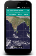
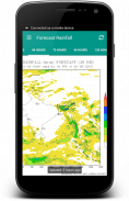
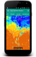
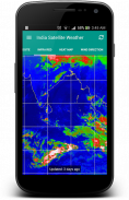
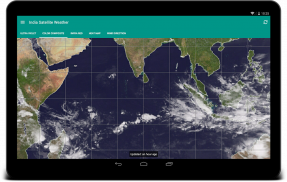
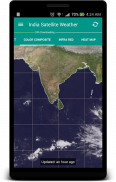
"A picture is worth a thousand words". A complex weather data can be conveyed easily with an image map. By observing the Cloud formations around your City, you can easily predict whether the day is going to be Hot or Rainy/Cloudy.
It is very well equipped with data caching capabilities and will never download duplicate data from the server. The downloaded weather maps will stored locally and can accessed offline.
This application fetches the weather maps directly from Indian Meteorological Department (www.imd.gov.in) and CIMSS [USA] (http://cimss.ssec.wisc.edu)
FYI: I really don't have control on the missing north indian region of some map types because they are provided by USA Meteorological Department.
This is an Open Source Application: https://github.com/Shahul3D/IndiaSatelliteWeather
Feel free to contribute!
"صورة تساوي ألف كلمة". يمكن نقل وبيانات الطقس المعقدة بسهولة مع مخطط صورة. من خلال مراقبة تشكيلات السحب في جميع أنحاء مدينة الخاص بك، يمكنك التنبؤ بسهولة ما إذا كان اليوم سوف تكون ساخنة أو ممطر / غائم.
وهي مجهزة بشكل جيد للغاية مع قدرات التخزين المؤقت البيانات ولن تحميل البيانات المكررة من الخادم. وتخزين خرائط الطقس تحميلها محليا ويمكن الوصول إليها حاليا.
يجلب هذا التطبيق الطقس خرائط مباشرة من ادارة الارصاد الجوية الهندية (www.imd.gov.in) وCIMSS [الولايات المتحدة الأمريكية] (http://cimss.ssec.wisc.edu)
لمعلوماتك: أنا حقا لا تملك السيطرة على المنطقة من شمال الهند في عداد المفقودين من بعض أنواع خريطة ليتم توفيرها من قبل ادارة الارصاد الجوية الولايات المتحدة الأمريكية.
هذا هو تطبيق مفتوح المصدر: https://github.com/Shahul3D/IndiaSatelliteWeather
لا تتردد في المساهمة!
India Satellite Weather - إصدار 5.0.6
(27-01-2020)
India Satellite Weather - معلومات APK
نُسخة APK: 5.0.6الحزمة: com.shahul3d.indiasatelliteweatherتطبيقات من الفئة نفسها
قد يعجبك أيضًا...


